
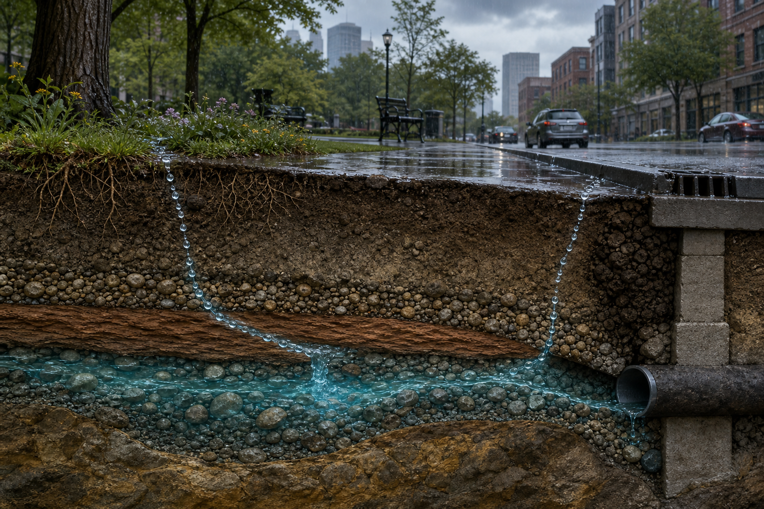
A Raindrop’s Underground Journey: How Water Rewrites the Ground Beneath a City
Imagine a raindrop arriving over a city during the first ten minutes of a summer storm. It lands on the glass roof of a bus shelter, joins a thin sheet of water, slips into a gutter and reaches the curb. Nothing about that route is accidental. Roof pitch, pavement, storm drains, tree pits and buried pipes have already negotiated much of the drop’s future.
A second drop lands only twenty meters away in a park. It clings to a leaf, falls onto mulch and disappears between grains of soil. From the street, the two drops seem part of the same rainfall. Underground, they may enter systems with different speeds, chemistry and destinations. One can reach a river within minutes; the other might spend months, years or far longer moving through the ground.
Following this imagined urban groundwater journey reveals a city that extends below its basements and subway platforms. Water travels through pores, fractures and engineered fill. It carries dissolved material, responds to pumping and changes the pressure that helps support sediments. In some places it slowly lowers the land. In others it dissolves rock and contributes to sudden collapse. The ground beneath a city is not a sealed foundation; it is a changing part of the water cycle.
The first fork: run off, wait or enter
When rain reaches a surface, it can run off, collect in storage, evaporate or infiltrate. The share following each route depends on rainfall intensity and duration, surface slope, vegetation, soil condition and how wet the ground already is. If rain arrives faster than the surface can admit water, excess water ponds or flows downhill. Saturated ground can also shed rain even when its soil would normally be permeable.
A road and an undisturbed patch of soil handle the same storm differently. Asphalt has very little capacity to admit water through its intact surface. Curbs concentrate runoff and drains export it. Soil offers openings, but those openings are not uniform. Roots create channels, burrowing organisms mix material and decayed organic matter builds aggregates. Compaction from vehicles or foot traffic can squeeze the larger pores and sharply reduce entry.
Infiltration is the crossing of the land surface. It is not automatically aquifer recharge. A drop may enter the upper soil and later be drawn into a root, return to the air, move sideways toward a drain or remain temporarily stored. Recharge occurs only when water continues downward far enough to replenish groundwater.
Through the unsaturated zone
Below the surface, the park drop enters the unsaturated zone. “Unsaturated” does not mean dry. Water coats grains and fills some pores, while air occupies others. Gravity pulls downward, capillary forces hold water against mineral and organic surfaces, and differences in moisture encourage movement. The route can be a slow seep through tiny pores or a faster shortcut through a root channel, crack or animal burrow.
Texture matters. Sandy material generally has larger connected spaces that can transmit water relatively quickly, though it may hold less plant-available moisture. Clay-rich material contains extremely small pores and can transmit water slowly, even while storing a substantial amount. Real urban ground is messier: imported fill, buried topsoil, construction debris and compacted layers can sit beside natural sediments. Two neighboring lots may therefore have very different underground plumbing.
Layers redirect the journey. Water moving through a permeable sandy layer may slow above a tighter clay layer and spread sideways. A small, temporary saturated body can develop above that barrier, called perched water. This helps explain why one basement corner stays damp while a deeper monitoring well shows a much lower regional water table.
Meeting the water table
If the drop escapes root uptake and continues downward, it may eventually reach the water table: the upper boundary of the zone where connected openings are saturated. The water table is not usually a flat underground lake. It is a sloping surface that rises and falls, often echoing the terrain in a subdued way. It can respond to seasons, drought, sustained recharge, river levels and pumping.
Below that boundary, groundwater moves from areas of higher hydraulic head toward lower head. Hydraulic head combines elevation and pressure; it is the energy condition that drives flow. The movement may be surprisingly slow in fine material and faster in coarse gravel or open fractures. A map of underground flow cannot safely be inferred from street slope alone because buried geology controls the available pathways.
An aquifer is not defined simply as rock containing water. Most subsurface material holds some water. An aquifer stores and transmits enough to be useful to wells or springs. Sand and gravel deposits, porous sandstone and well-connected fractured rock can form aquifers. An aquitard is a less permeable layer that restricts movement. Alternating aquifers and aquitards create a three-dimensional system rather than one universal pool beneath the city.
Unconfined, confined and fractured routes
In an unconfined aquifer, the water table forms the upper boundary and recharge can arrive from above where materials permit. A confined aquifer lies beneath a low-permeability layer, and its water is under pressure. Recharge may occur far away where the aquifer reaches the surface or connects to more permeable deposits. A city well can therefore withdraw water that entered the ground beyond the city and long before the current storm.
Fractured-rock aquifers add another complication. Water may be stored in tiny openings in the rock but move mainly through connected cracks, joints and faults. One fracture can transmit water readily while nearby intact rock transmits little. In soluble rocks such as limestone, movement along fractures can enlarge openings over time, producing conduits and caves associated with karst terrain.
The imagined drop’s travel time cannot be guessed from depth alone. A preferential path may carry it rapidly past much of the soil, while a tightly held portion barely moves. Groundwater age in a single well can also be a mixture because the well draws from multiple pathways. The underground journey is better pictured as branching probabilities than as one blue arrow.
What pavement changes
Urbanization replaces many permeable patches with roofs, streets and compacted ground. During storms, runoff can become faster and more concentrated, raising peak flows in receiving channels. Less water enters through the covered area, but it is too simple to conclude that a city always has uniformly less recharge. Leaking water mains, irrigation, detention basins and seepage from altered channels can add infiltration in particular places.
The result is redistribution. Recharge may decline across a paved district while becoming concentrated in a park, swale, cracked channel or basin. Concentrated water can be useful when a site is designed for infiltration, but it can also interact with contaminated soil, unstable fill, buried structures or a shallow water table. A feature that works well in deep, permeable soil may be unsuitable above a basement, steep slope or vulnerable karst.
Permeable paving, rain gardens, tree trenches and infiltration basins aim to slow and admit more stormwater. Their success depends on soil testing, pretreatment of sediment, adequate distance from structures and underground utilities, and long-term maintenance. Clogged surfaces lose capacity. Good design treats an infiltration feature as working infrastructure, not a decorative depression that can be forgotten after installation.
The chemistry picked up along the way
Rain begins acquiring dissolved and suspended material as soon as it contacts air and surfaces. On a street it may encounter fine tire and pavement particles, metals, nutrients, deicing salts, oils, litter and microbes. In soil, some compounds attach to particles, some are transformed by microorganisms and others remain mobile. Soil can moderate contamination, but it is not an unlimited filter.
Fast pathways are especially important. A crack, abandoned well or highly permeable gravel trench can bypass reactive soil and carry water downward quickly. Conversely, very slow flow provides more contact time but does not guarantee that every contaminant will be removed. Chemical behavior depends on acidity, oxygen conditions, minerals, organic matter and the compound itself.
This is why protecting recharge areas matters even when a drinking-water well is distant. Groundwater problems can emerge long after the activity that initiated them, and cleanup below ground is difficult. The invisible travel time that makes an aquifer useful during drought can also delay evidence of contamination.
When pumping changes the ground
A well lowers hydraulic head around itself when it removes groundwater. Nearby water begins moving toward the well, creating a three-dimensional zone of drawdown. If withdrawal remains within what the system can accommodate, levels may stabilize or recover. If pumping persistently exceeds replenishment and inflow, groundwater levels decline.
In aquifer systems containing compressible silt and clay, declining water pressure shifts more of the overlying weight onto the mineral framework. Fine-grained layers can compact. The land surface above may sink gradually, a process called subsidence. Some elastic compression reverses when pressure recovers, but compaction can also be permanent, reducing the aquifer system’s future storage capacity.
Subsidence is rarely as visually dramatic as a sudden hole. It can accumulate across a broad area, changing drainage gradients, reducing flood protection and stressing wells, roads, pipelines, canals and building foundations. Different parts of a city may settle at different rates, making relative movement more damaging than a uniform drop.
Why a sinkhole is not simply fast subsidence
Subsidence is a broad term for lowering of the ground, and sinkholes are one form of it. Yet the mechanisms need to be distinguished. Aquifer-system compaction can lower a wide region without creating an open cavity. A classic sinkhole develops where soluble bedrock or other underground voids allow overlying material to move downward.
In karst terrain, slightly acidic water dissolves limestone along cracks over long periods, enlarging channels and cavities. Soil can gradually settle into an opening, producing a depression, or a bridging layer can fail abruptly and create a steep-sided collapse. Changes in drainage, construction loading, leaking pipes and groundwater levels may alter the balance at a susceptible site, but a surface hole cannot be diagnosed from appearance alone.
Not every circular depression is a geological sinkhole. Broken utility lines, poorly compacted trenches, decayed buried material and failed drainage structures can create similar features. Filling a hole without determining its mechanism may conceal continued movement and redirect water into a worse path.
The city as an underground obstacle course
Basements, retaining walls, subway boxes, utility corridors and parking structures interrupt natural flow. Water can pile up on the uphill side of a low-permeability structure or be guided along a gravel utility trench. Construction dewatering temporarily lowers groundwater to keep an excavation workable; the change must be planned because nearby soils and foundations may respond.
Tunnels and deep foundations also meet groundwater under pressure. Engineers design drainage, waterproofing and structural resistance for expected conditions, but the conditions can change as neighboring projects, pumping and climate patterns alter water levels. A leak seen inside a structure is therefore both a building problem and a clue about the surrounding groundwater system.
Streams reveal another connection. Groundwater can discharge into a channel and maintain flow between storms, while a stream may lose water into the aquifer elsewhere. Lining, burying or deepening an urban channel can change that exchange. The raindrop that vanished in the park might eventually emerge in a river rather than remain stored indefinitely.
How residents can observe without diagnosing
Ordinary observations become useful when they are dated and compared. Note whether ponding lasts longer after similar storms, a depression is expanding, doors begin sticking, pavement cracks change width or a basement leak corresponds to rainfall. Photograph from the same safe location with a fixed object for scale. Keep records of plumbing repairs, nearby excavation and changes to drainage.
These signs do not prove groundwater decline, sinkhole formation or foundation failure. Expansive soil, leaking utilities, poor surface drainage, tree roots and construction settlement can produce overlapping symptoms. Do not enter a depression, probe a cavity or redirect large flows toward a neighboring property. Sudden ground movement, exposed utilities, structural distortion or an opening near a building or roadway calls for immediate isolation of the area and qualified assessment.
At the neighborhood scale, monitoring wells, stream gauges, precise land-elevation measurements and geological mapping reveal patterns that a single property cannot. Engineers and Earth scientists combine those measurements with boring records, pump data and rainfall history. A reliable interpretation comes from converging evidence, not one dramatic crack.
Designing a better ending for the drop
A water-aware city keeps several goals in view: reduce damaging runoff, replenish suitable aquifers, protect groundwater quality and avoid directing water into unstable ground or vulnerable structures. That requires matching each intervention to local geology. Storage and slow release may be appropriate where infiltration is unsafe; carefully designed recharge may be valuable where soil, water quality and underground conditions support it.
Maintenance is as important as construction. Clearing sediment, checking inlets, repairing leaks and tracking performance preserve the intended route. Pumping plans can account for long-term water levels and land movement. Development reviews can protect recharge areas and avoid concentrating drainage above known cavities.
Our park raindrop has no single ending. It may return to the atmosphere through a tree, enter a shallow aquifer, join a stream or move slowly toward a well. Its significance comes from joining billions of other drops, each routed by the same surfaces and layers. Together they recharge water supplies, transport material, change underground pressure and, over time, help rewrite the elevation and stability of the city above.